The agriculture sector holds paramount importance due to its great impact on the economic development of a country. In this regard, several technology-based smart systems are being used worldwide to increase the crop yield with resources optimization. These systems are based on cutting edge technologies such as Internet of Things (IoT), machine learning, and remote sensing as discussed by Shafi et al [1]. The IoT based smart agricultural systems provide real-time status of the environmental variables relating to the crop using low-cost sensors which have the capability to communicate with the remote server. Such systems are generally suitable for small to medium scale farming due to their sensitivity to the high maintenance & deployment cost and power constraints. In contrast to IoT, remote sensing is widely used for large scale farming which is based on reflective analysis of satellite images. However, the images obtained by satellite platforms have low resolution with large area coverage and long revisit time which make them suitable for large scale farming. To overcome these limitations, low altitude platforms such as drone with on-board imaging sensors are used, where these platforms provide high-resolution images and flexible data acquisition. In view of the above, we developed an agricultural monitoring system at ‘Internet of Things (IoT) Lab’ which is deployed in the experimental field located in National Agricultural Research Center (NARC), Islamabad as shown in Figure 1.
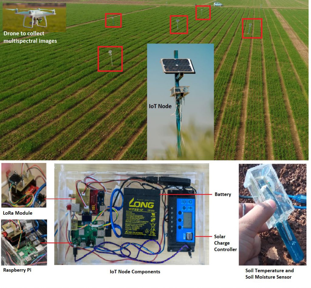
The IoT nodes consist of different sensors that collect the environmental parameters such as air temperature & humidity; and soil parameters including soil moisture and soil temperature. These IoT nodes are deployed across the wheat field in a star topology, where a master node receives the data from all slave nodes using the low-power wide-area (LoRa) communication module, and all collected data is sent to the web portal using GSM technology. Initially, the effect of environmental parameters and soil parameters on crop health is investigated in [2] which helps to identify the most influencing parameters for the wheat crop. Additionally, a drone with an onboard multispectral camera is used to collect multispectral images which helps to identify the stressed areas by computing Normalized Difference Vegetation Index (NDVI) which provide useful insights about the chlorophyll content of crop. Conventionally, NDVI is used for monitoring crop vigor but it only provides the health information based on chlorophyll value, whereas, for a detailed crop health representation, the data from multiple sources are required such as soil moisture, soil temperature, humidity and air temperature
To provide a rich representation of crop health, a multi-source data integration approach is used that combines IoT and drone technology to enhance the representation of crop health information compared to the crop health status depicted only by NDVI as discussed in [3]. Figure-2 shows the architecture of the implemented system.
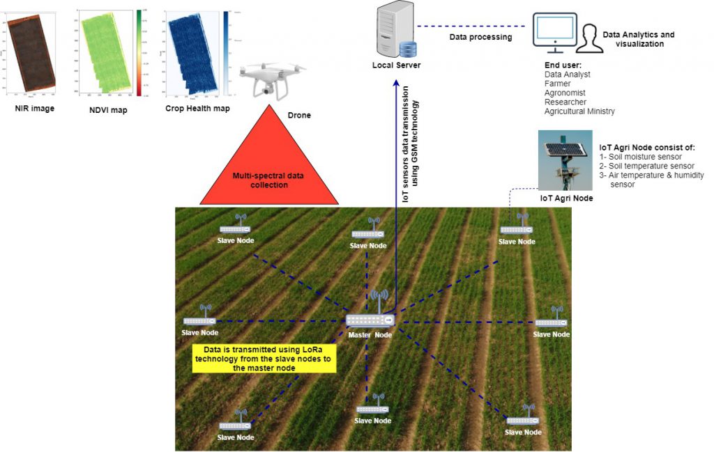
The collected data from IoT nodes and drone is combined at different growth stages of the crop whereas machine learning models are applied to the combined data to generate crop health maps. These models include Support Vector Machine (SVM), Naïve Bayes (NB), Neural Network (deep and shallow) where deep Neural Network model with two hidden layers outperformed other models with the highest accuracy of 98.4%. The generated health maps assisted in localizing the area under stress, where the IoT sensors data maps provided insights for identifying the factors affecting crop health.
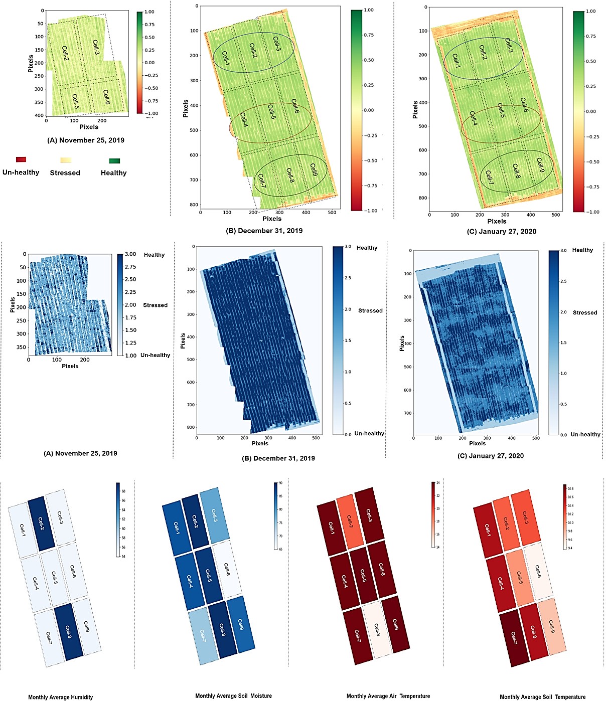
Figure-3 shows the NDVI maps, health maps, and IoT sensors data maps for different crop stages. The stressed areas shown in NDVI maps are clearly visible in the health maps, where the IoT sensors data maps show the variation of environmental parameters and soil parameters for the month of January 2020. In [1], we presented a review of the existing smart agricultural solutions, latest & traditional techniques, different vegetation indices to assess the crop health, platforms for data collection, and the role of machine learning & deep learning in the agriculture domain. In [2], we developed a complete system for crop health monitoring where IoT nodes are developed to collect environmental and soil parameters. The collected IoT data is analyzed to find the variation in soil parameters with reference to the environmental parameters. Moreover, the drone is used to collect high-resolution multispectral images where NDVI is computed to find the area under stress. In [3], a system for crop health monitoring has been proposed which is based on the integration of the latest technologies such as drone-based remote sensing, IoT, and machine learning. The multi-modal data was collected from different sources including IoT sensors and a drone with a multispectral camera mounted on it. The collected data from two heterogeneous sources were mapped into the same temporal resolution and labeled to generate health maps. In addition to this, IoT sensors data maps were generated to correlate the environmental variation with the crop health status delineated in the NDVI maps, where these maps provided useful insights about the factors influencing the crop health.
References:
[1] Shafi, U., Mumtaz, R., García-Nieto, J., Hassan, S. A., Zaidi, S. A. R., & Iqbal, N. (2019). Precision agriculture techniques and practices: From considerations to applications. Sensors, 19(17), 3796.
[2] Shafi, U., Mumtaz, R., Hassan, S. A., Zaidi, S. A. R., Akhtar, A., & Malik, M. M. (2020). Crop Health Monitoring Using IoT-Enabled Precision Agriculture. In IoT Architectures, Models, and Platforms for Smart City Applications (pp. 134-154). IGI Global.
[3] Shafi, U., Mumtaz, R., Iqbal, N., Zaidi, S. M. H., Zaidi, S. A. R., Hussain, I., & Mahmood, Z. (2020). A Multi-Modal Approach for Crop Health Mapping Using Low Altitude Remote Sensing, Internet of Things (IoT) and Machine Learning. IEEE Access, 8, 112708-112724.
The author is the Director at Internet of Things (IoT) Lab and is also an Assistant Professor at NUST School of Electrical Engineering and Computer Science. She can be reached at rafia.mumtaz@seecs.edu.pk