


Introduction
Agriculture is the backbone of Pakistan’s economy, with rice and wheat feeding millions and driving rural livelihoods. Yet, farmers and other relevant stakeholders (policymakers, crop breeders, researchers) alike face a common challenge: knowing the right time to sow, irrigate, and harvest crops. Traditionally, this knowledge has been based on experience and local weather patterns. But what if we could track the growth of our staple crops across the entire country, much more quickly and accurately, without even stepping into the fields? That is the vision behind PEEOS (Phenology Estimation of Rice and Wheat in Pakistan using Earth Observation Satellite Imagery), a groundbreaking project led by researchers at the Machine Vision & Intelligent Systems (MachVIS) Lab at SEECS, NUST.
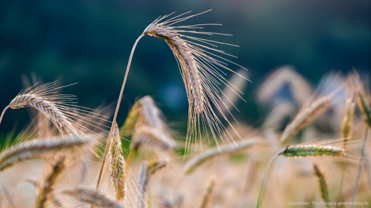
Phenology is the science of tracking plant life cycles, such as when wheat sprouts, when rice flowers, and when the harvest season begins. These “crop calendars” are critical for boosting yields, saving resources, and planning national food security at a large scale. Thanks to satellites orbiting hundreds of kilometers above the Earth, the PEEOS project has developed new ways of observing Pakistan’s fields from space. Using advanced machine learning techniques and artificially intelligent models, the team can now map when crops are planted, how they develop, and when they are ready for harvest, with remarkable accuracy.
Why This Matters?
Pakistan’s food system has been under significant stress. Climate change has made weather patterns unpredictable, while water shortages threaten irrigation-dependent crops. Meanwhile, a growing population means we must produce more food on the same land. Knowing exactly when crops reach different growth stages helps farmers use water more efficiently, apply fertilizer at the right time & right places, and schedule harvests to reduce losses. At the national level, this technology allows us to estimate yields months in advance, manage food reserves, and plan imports or exports accordingly. All of this lets us predict a potential bumper wheat harvest in Punjab or anticipate a potential rice shortfall in Sindh before it actually happens on the ground. This is the kind of practical information PEEOS delivers.
How It Works (Novelty of the Research)
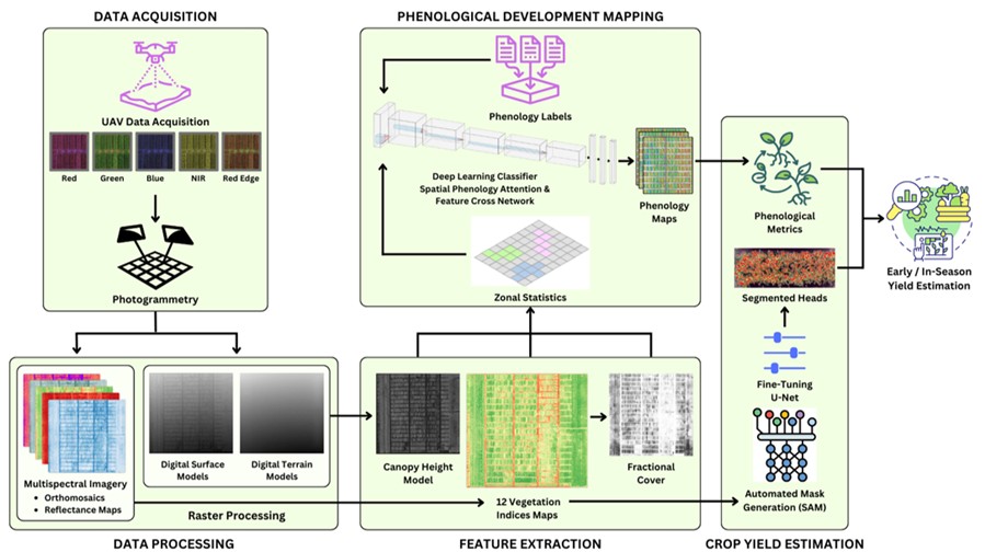
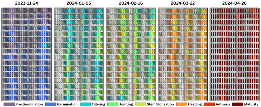
The project makes use of satellite imagery that captures light in the multispectral range invisible to the human eye. Crops reflect sunlight differently at each stage of growth. By analyzing these patterns and spectral signatures across large areas, this project builds a timeline of crop development over their entire growing seasons. Machine learning and deep learning models trained on both field data and satellite signals across multiple seasons ensure accuracy, even in regions where weather clouds or dust storms may block the view in some timestamps. This system does not just stop at monitoring. We create crop maps and link the phenological performance of a crop with its final yield outcome. This can highlight regions at risk of delayed growth, pest vulnerability, or poor harvest. These maps are accessible and can be further scaled for use by local farming communities in the future.

Achievements and Impact
The project successfully produced crop maps and phenology maps for rice, wheat, and sunflower across Pakistan through both satellite and UAV imagery, covering major cultivation zones. These maps have been validated against on-ground data and show strong accuracy in predicting planting and harvesting windows.
One of the biggest achievements of PEEOS is creating a scalable framework that can be expanded to other crops and regions. The technology is flexible enough to integrate weather forecasts, soil data, and irrigation information, providing a complete picture of the farming landscape. For farmers, this means timely advisories. For researchers, it opens the door to advanced agricultural modeling. And for national planning bodies, it provides a science-backed foundation to ensure food security in Pakistan.
The Road Ahead
PEEOS has laid the foundation for a smarter, climate-resilient agriculture system in Pakistan. In the future, this technology can be scaled into mobile applications where farmers receive real-time alerts about the best time to irrigate or harvest. It can also be linked with global climate models to forecast how future weather changes will impact their crop cycles. By turning satellites into practical “eyes in the sky” for agriculture, Pakistan is taking a bold step towards modernizing its farming practices. Projects like PEEOS not only strengthen food security but also demonstrate how science and technology can serve everyday people, from a farmer in a remote village to a national decision-maker planning the nation’s grain reserves. In essence, this is more than just a research project. It is a promise: that with innovation and vision, Pakistan can rise to meet the challenges of tomorrow’s agriculture.
Video Demonstration of Project
Collaborating Institutions
- National Agricultural Research Centre, Islamabad, Pakistan
- Robotics Research Lab, RPTU, Kaiserslautern, Germany
- ICESCO Chair of Data Science & Analytics at NUST
- Higher Education Commission (HEC), Pakistan
Acknowledgement
This work is supported by the Higher Education Commission (HEC) of Pakistan under NRPU Project ID: 15664, titled “PEEOS: Phenology Estimation of Rice and Wheat in Pakistan using Earth Observation Satellite Imagery”.
References
- Ali, M., Athar, U., Zafar, Z., Khattak, H.A., Berns, K., & Fraz, M. M. (2025, August). Combining UAV Multispectral Data & Crop Morphological Features For Sunflower Oil Content Estimation. In 2025 45th IEEE International Geoscience and Remote Sensing Symposium (IGARSS). IEEE.
- Athar, U., Ali, M., Zafar, Z., Khurshid, H., Berns, K., & Fraz, M. M. (2025, May). Sunflower Lodging Detection and Monitoring Through UAV-Based Multispectral Data. In 2025 International Conference on Innovation in Artificial Intelligence and Internet of Things (AIIT) (pp. 1-7). IEEE.
- Ali, M., Athar, U., Zafar, Z., Berns, K., & Fraz, M. M. (2024, November). Water Stress Diagnosis in Rainfed Wheat Through UAV Multispectral Imagery and IoT Data. In 2024 19th International Conference on Emerging Technologies (ICET) (pp. 1-7). IEEE.
- Athar, U., Ali, M., Zafar, Z., Berns, K., & Fraz, M. M. (2024, November). Analyzing Phenological Progression in Wheat Genotypes Through UAV Multispectral Imagery. In 2024 19th International Conference on Emerging Technologies (ICET) (pp. 1-9). IEEE.
- Sabah, N. U., Zafar, Z., Satti, F. A., Berns, K., & Fraz, M. M. (2024, October). Enhancing Cotton Crop Mapping in Pakistan: Integrating Transfer and Active Learning with Remote Sensing Technologies. In 2024 4th International Conference on Digital Futures and Transformative Technologies (ICoDT2) (pp. 1-8). IEEE.
The author is a Tenured Professor at the School of Electrical Engineering and Computer Science (SEECS), National University of Sciences and Technology (NUST), Islamabad, Pakistan. He can be reached at [email protected].
Research Profile: https://bit.ly/45ub1BF

![]()