


In the era of Industry 4.0, small-scale farmers are under growing pressure to keep pace with large-scale agribusinesses. To remain competitive, they are increasingly expected to adopt advanced tools such as precision agriculture, data analytics, and automation, technologies that improve yields, optimize resource use, and increase efficiency. But adopting these innovations isn’t straightforward. Each stage of the farming cycle, from pre-season soil analysis using satellite data and GPS mapping to variable-rate planting, automated seeding, crop surveillance, and AI-driven insights, demands specialized technologies from multiple providers. This fragmented ecosystem forces farmers to coordinate with multiple vendors, often needing several to cover basic operations. Such a fragmented approach is not only costly and inefficient but also a major barrier to adoption. To overcome this, farmers need integrated solutions, robust support systems, and accessible training to navigate these platforms. Building trust and streamlining access to these innovations is essential for small farmers to thrive in a rapidly evolving agricultural landscape.
PakAgri
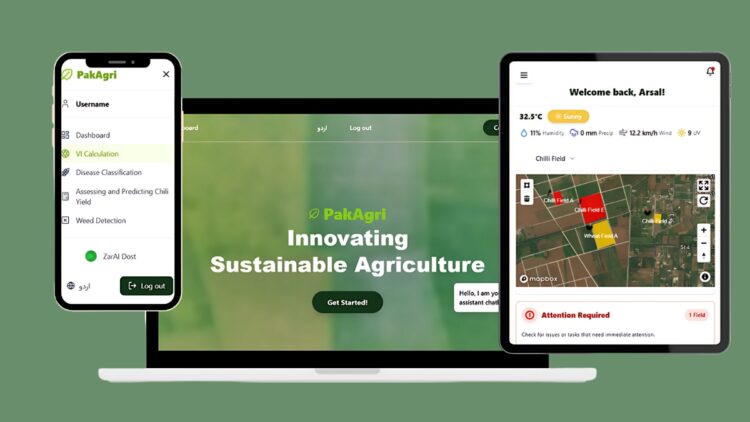
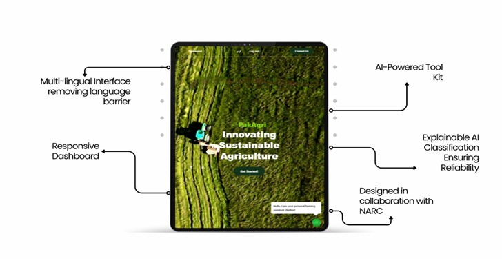
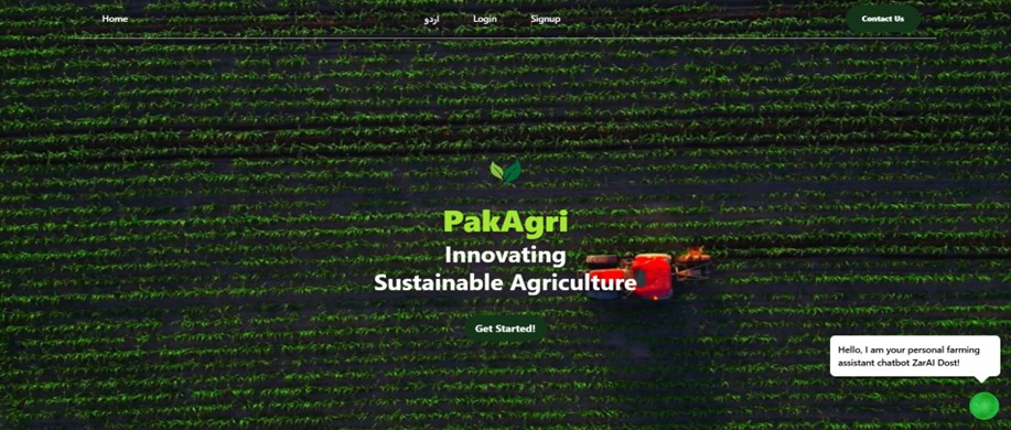
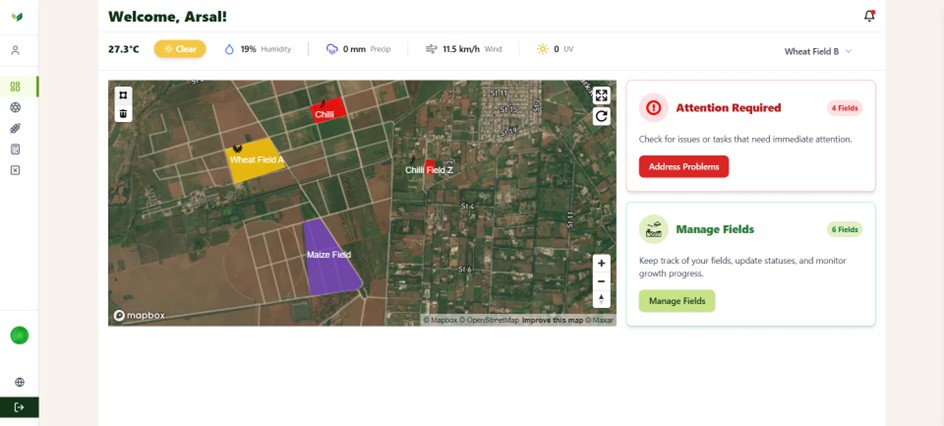
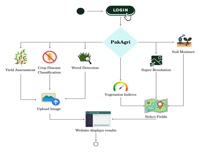
Introducing PakAgri (Figure 1), a comprehensive platform designed to meet all agricultural needs, supporting farmers from pre-seeding to post-harvest with cutting-edge technologies and evidence-based solutions. By consolidating essential services into a single, user-friendly system, PakAgri eliminates the hassle of dealing with multiple vendors. It also supports collaboration with agricultural researchers to deliver scalable, multilingual solutions made for global impact and progressive farming practices. Data for our models is locally sourced from the National Agriculture Research Center, ensuring its relevance to local conditions. PakAgri system provides a farmer with complete end-to-end capabilities. Our multi-lingual landing page (Figure 2), equipped with a chatbot that responds to questions both in Urdu and English, guides users through our features and is responsive on a laptop, tablet, and mobile screens. Through the interactive and easy-to-use dashboard (Figure 3), farmers are able to manage their farms by creating individual fields on the map available through our dashboard. They can perform various activities highlighted by Figure 4.
Wheat Disease Detection
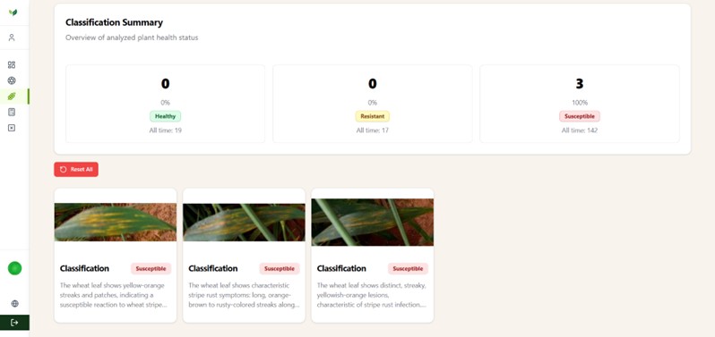
Wheat plays a vital role in meeting the rising global demand for food as the world’s population continues to grow. As one of the most extensively grown crops worldwide, it contributes approximately 20% of the daily caloric intake for people around the globe. Wheat stripe rust is a highly destructive fungal disease that can severely damage wheat crops. If uncontrolled, it has the potential to kill up to 75% of infected plants, leading to significant yield losses. PakAgri platform offers individuals with ability to upload pictures of wheat plants, after which it localizes and classifies leaves into three categories with descriptions. Figure 5 shows the website page for wheat disease detection.
Chilli Yield Estimation
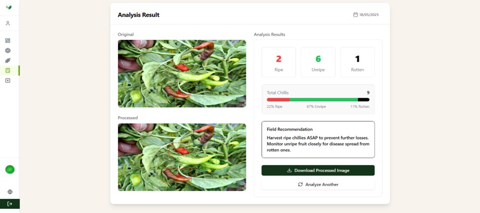
Accurate estimation of chilli yield is crucial to ensure efficient use and prevent wastage. However, conventional methods are slow and labor-intensive, relying on weighing the chillies to determine yield. This process is also destructive, as it often involves uprooting the plants. The chilli yield estimation tool detects chillies in complex, natural backgrounds. Specifically tailored to identify unripe (green) chillies and distinguish them from similarly colored surroundings, the model accurately determines the total number of chillies in an image. This enables farmers to get an accurate count without the need to uproot plants to weigh them. Figure 6 showcases the results displayed by our website.
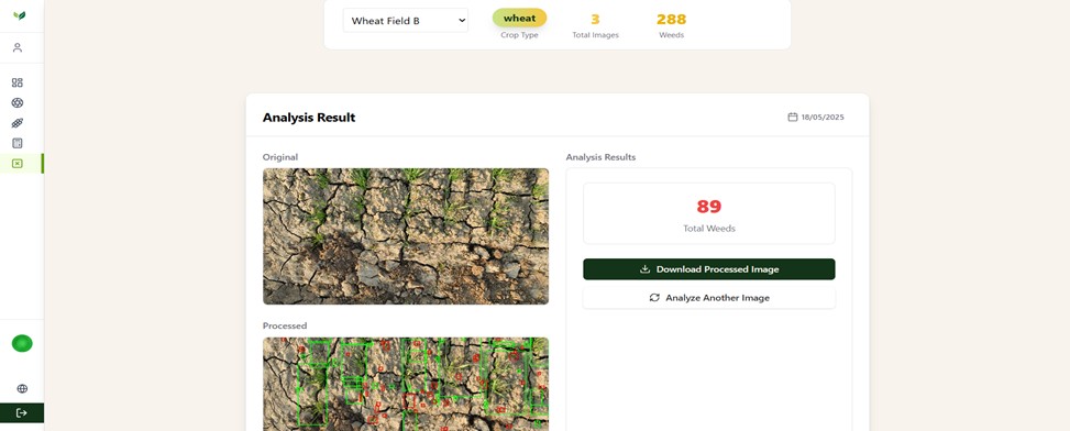
Weed Detection
Weeds pose a significant threat to crop health by competing for key resources like sunlight and water. Ensuring high crop yields depends heavily on effective weed control. A critical step in this process is accurately identifying and separating weeds from the actual crops to avoid unintentional harm. While manual identification is feasible, it is often unreliable due to the dense weed population and their typically small size. PakAgri platform provides a generalized weed identification tool to distinguish crops and weeds of any species from crop row images and provides reliable estimates of weeds in the fields. Figure 7 shows the weed detection results obtained by PakAgri.
Super Resolution
Super resolution helps enhance low-resolution images by upscaling them to higher quality. This is especially valuable for satellite imagery, where freely available data is often too low in resolution to be effective for small-scale analysis. PakAgri platform offers access to super-resolution capabilities via a dedicated endpoint, with full details available on the website.
Vegetation Indices
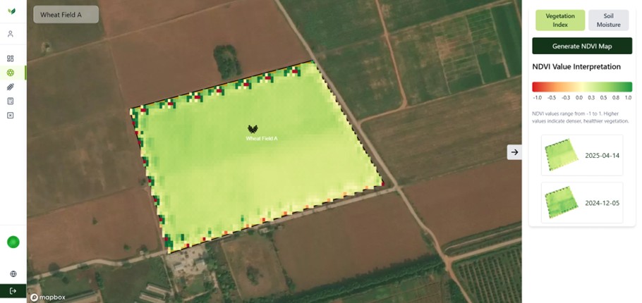
Vegetation indices serve as key indicators for assessing the health of crops and soil. Among them, the Normalized Difference Vegetation Index (NDVI), introduced in 1973, has become a foundational tool in satellite image analysis. Today, NDVI remains widely used, especially in regions with extensive vegetation coverage, due to its effectiveness in monitoring plant health and growth patterns. PakAgri allows users to extract NDVI data across various periods and visualize it directly on their fields. This enables them to track and compare historical NDVI trends for each field individually, providing valuable insights into vegetation health over time. Figure 8 shows the page to overlay vegetation onto field maps.
Soil Moisture Mapping
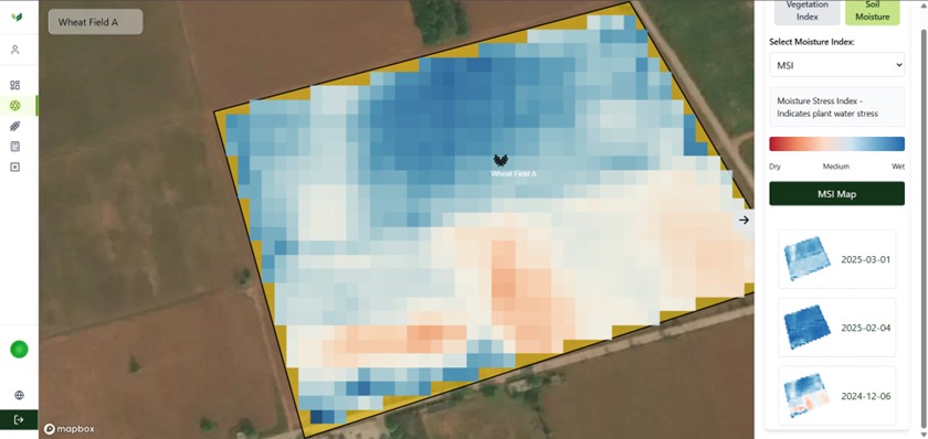
Soil moisture maps serve as important decision makers for irrigation and moisture control. They prevent crops from drying up, as well as ensuring that no water is wasted. PakAgri platform provides users the ability to generate historical soil moisture data and compare it by overlaying it onto their fields. Figure 9 shows the soil moisture map overlaid onto the field.
Overall, PakAgri currently offers five different services for farmers. In the future, the services will be further expanded and additional modules will be integrated to enhance the platform’s capabilities, improve decision-making, and support sustainable and efficient farming practices across diverse agricultural landscapes.
The author is a Tenured Professor and Associate Dean at the School of Electrical Engineering and Computer Science (SEECS), National University of Sciences and Technology (NUST), Islamabad, Pakistan. She can be reached at [email protected].
The co-authors include Miss Syeda Eman Fatima and Syed Arsal Rahman, Research Assistants at Pak Thai Digital Innovation Lab, SEECS ([email protected], [email protected])
Research Profile: https://bit.ly/3VSfmIO
![]()